Removing maps from bus stops and the digital divide
Today the response that you will likely get to any query to Public Transport Victoria (PTV) will advise you to use the website, app or journey planner. Much of the advertising and marketing also attempts to send people in this direction.
This push to get everyone to use digital tools has accelerated over the past few years.
While digital information and tools are very useful, they will never be a complete substitute for high-quality ‘real life’ passenger information.
The key point here is that computers cannot understand or display information unless it is told to them by humans. There are many nuances and attributes specific to locations that need careful understanding to both process and display information that is readable and useful for people.
The end result in the case of public transport is that incorrect, misleading or confusing information is given to passengers. This creates bad experiences. We know this then leads to people avoiding public transport and perpetuates negative perceptions.
There is a lot to talk about with this topic and I have written before about some of the many issues with the quality of information put out by PTV.
This time I want to zoom in on bus stops.
To cut a long story short, most bus stops in Melbourne used to contain maps of the local area.

Then PTV began removing these from almost all bus stops. They were replaced with either nothing or advertising information – even when it was quite useless.

Some stops were lucky enough to get a schematic route diagram showing major stops. While this is better and does serve a purpose, it is not a map nor does it show nearly as much information as it did previously.
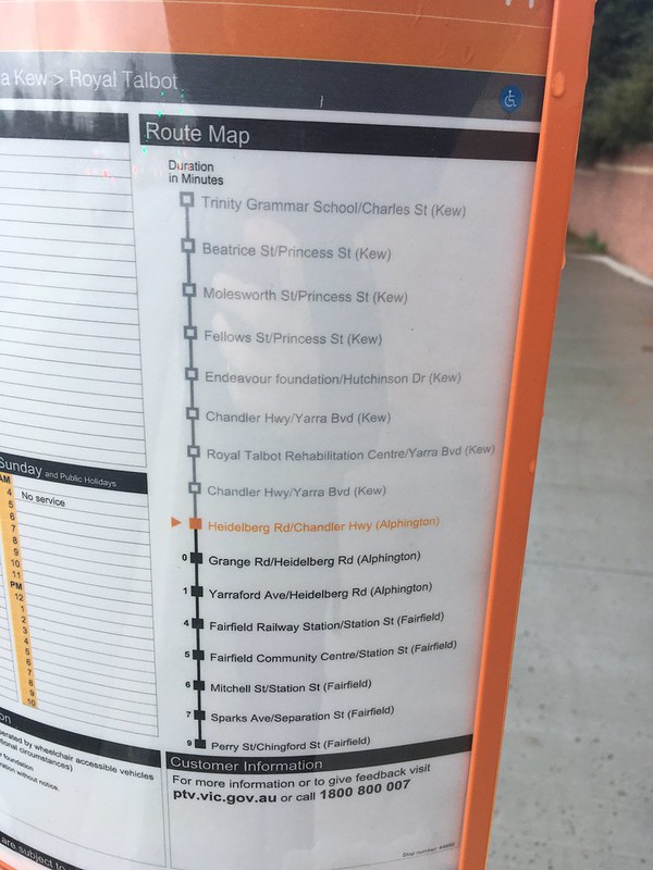
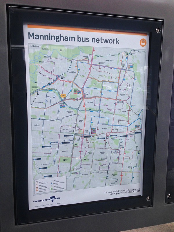
The only ones spared or refreshed were at some major interchanges. The few new maps that did go up were actually very good.
While there was no public statement or information provided by PTV on this program, I can only assume that the reason for doing this was to reduce costs. Revising and replacing hundreds of local area maps across Melbourne would be time-consuming and need resources to complete.
However, I would argue that this would be time and money well spent. There are many scenarios where a map on a bus stop would be useful. Tourists trying to orient themselves in a new area, less frequent passengers getting to their final destination, and people who are unable to use a phone to access digital information for whatever reason.
I should add that this same scenario has played out at tram stops as well, with the same issues and drawbacks.
The new maps implemented at major bus stops and interchanges show that the capability definitely exists within PTV to bring physical maps back to most, if not all stops. I understand that we need to spend time and money where it is most needed as well. But if we want more people to use public transport, then removing or degrading physical information is not going to help.
2 Comments
Join the discussion and tell us your opinion.
Absolutely agree with you on this one!
A good quality map on a bus line can be as helpful for pedestrians as well as bus commuters. Tech fails! Recently in Melbourne my phone battery died while I was trying to find an address in an unfamiliar neighbourhood. Bus stop map would have been perfect. I thought I could solve my problem by checking the street directory in the yellow pages at a couple of local stores… it turned out they don’t bother to keep those any more… Use your phone they said!
Advertisers place their message where it gets noticed by the market. What advertiser would ask potential patrons to check their website? Only a monopoly, which PTV is not because of competition from cars and rideshare. PTV has its own advertising space at train stations and bus interchanges, where it should be trying to onsell bus connections to existing train users. Who knows where many of thse wondering buses go? It’s not easily found on the PTV website other than for transit nerds.