
Today I decided to try a new bicycle route through the middle eastern suburbs. This essentially consists of a big loop from North Balwyn down to Ashwood and returning north via Gardiners Creek and Bushy Creek in the City of Whitehorse.
For some reason, Google Maps doesn’t like custom map directions and won’t embed the custom markers. Mapbox also doesn’t appear to have the capacity to display custom routes. If anyone has any tips, please let me know. Until then, here’s a link to my route: https://goo.gl/maps/5kBX2nqPdCu
(Note: I’ve set a 1km privacy radius around my house, so the 241 Belmore Road address is just a random spot in North Balwyn – it’s not actually where I live).
North Balwyn – Ashwood
The first leg of the loop was the most familiar to me. Riding along the Anniversary Trail from Whitehorse Road, Balwyn, all the way down to the end at Alamein Railway Station and onward to Warrigal Road, Ashwood.

After riding through Canterbury, I came past the only section of the trail that currently requires an on-road section. This is the infamous ‘missing link’ in the Anniversary Trail near Camberwell High School in Camberwell. At the moment, bike riders and pedestrians have to ride/walk down Spencer Road, which is quite unsafe. A number of serious crashes between cars and bicycles have been reported at the Spencer Road/Prospect Hill Road intersection.
In April year, Boroondara Council voted to finally build an off-road path linking these two sections together. Despite some opposition from a few local residents and park users, the path was approved (very happy to say that I was one of those who voted in favour, although not in favour of retaining the carpark in the park).
After crossing Riversdale Road, I found another of the increasing number of bicycle repair stands installed by Boroondara Council next to Hartwell Railway Station. The City of Boroondara now has more of these great facilities than any other municipality in Melbourne to date, but they are being rapidly taken up in other areas.

The path continues across Toorak Road (probably the worst crossing along the entire trail) and High Street, Ashburton, connecting with the Gardiners Creek Trail just behind Alamein Railway Station. Here there is a good pedestrian/bicycle priority crossing where road vehicles must give way to path users. Unfortunately, there aren’t any speed humps to slow vehicles down like in North Kew, but it is well-designed nonetheless.

Signage here is a bit confusing. I half-guessed a left-turn here to follow my route (turns out I was right) and ended up riding past the Markham public housing estate. The state government is proposing to redevelop the site which has caused quite a bit of controversy in the local community.

This path took me to the end of this first leg at the Warrigal Road bridge across Gardiners Creek, with a nicely designed shared path to cross the creek/drain onto the Stonnington side of the border.

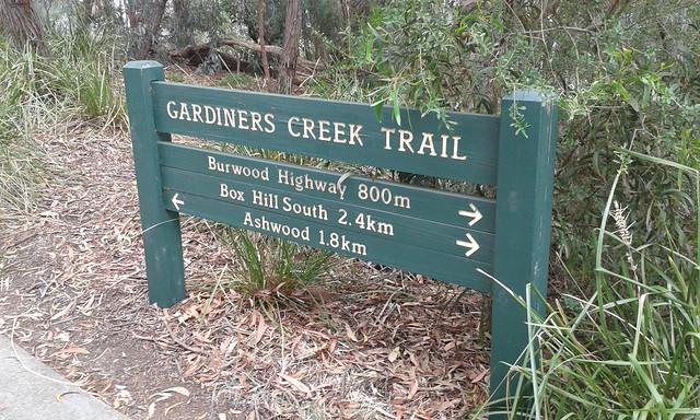
Ashwood – Box Hill South
This point marked the most southerly part of my route. The Gardiners Creek Trail winds through peaceful bushland and wetlands and slowly turns north.
At Highbury Road, the path begins to go uphill again. There is also an interesting ‘Local History Park’ that contains different areas that visually show the major stages in the development of the area. The park begins with a ‘fossil path’ consisting of a series of small pillars showing different types of ancient fossils from prehistoric times.

The next section of path was thoroughly confusing. I am pretty unfamiliar with this part of Melbourne and I wasn’t sure which route to take to get across the Burwood Highway and continue along the Gardiners Creek Trail to Box Hill. At the end of this bridge there were two signs which didn’t provide very clear directions at all. This end of the park also included signs and sculptures reflecting the drive-in cinema that used to exist in this location.

After the bridge, I decided to continue straight along the trail where another faded sign directed me into the wall of a power substation (no I didn’t actually run into it).

I asked for directions from a passing cyclist, who very kindly showed me the way from here all the way up to Canterbury Road (that’s him in the red).

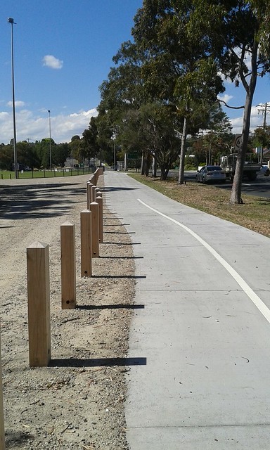
During a small section of on-road cycling just after crossing Station Street in Box Hill South, there was a nice touch of good bicycle infrastructure. The street had been blocked off to traffic but two lanes going through the sides of the barrier allowed both bicycles and water to go through. If we are serious about making residential side streets more bicycle-friendly and generally less dominated by cars, we need a lot more initiatives like this one.

After crossing Canterbury Road and following the shared path up Middleborough Road, I bid farewell to my fellow cyclist as he continued through to Blackburn along the path, while I had to go on up to Whitehorse Road to access Dorking Road and eventually the Bushy Creek Trail.
Box Hill South – North Balwyn
This was definitely the least pleasant part of my ride. Because there is no north-south off-road connection to Box Hill for some reason, the only reasonable way was to go up Middleborough Road. But there is no provision for bicycles whatsoever along this section of road. Combined with the steep uphill incline and a 60km/h speed limit, I wasn’t game to risk my life to join the general traffic so I opted to walk my bike up to the railway line.

The bridge over the railway line wasn’t much better, with narrow footpaths and slightly narrowed lanes making it even worse for cyclists and pedestrians. I also saw a truck harassing a bike rider on the road, complete with a very close pass at 60 km/h. I couldn’t see the license plate, but I’ve since reported the driver to the company that was displayed on the side of the truck. Seeing this incident didn’t exactly fill me with confidence about riding on this part of the road, so I kept walking.

Upon reaching Whitehorse Road, things started to look at lot better. There is a service lane on either side of the highway which provides a perfect low-speed environment for cyclists. While this could definitely be developed a lot more (there is plenty of room for a separated bicycle path and/or a lower speed limit), it’s much better than trying to brave the two lanes of fast-moving traffic on the main road.

Turning down Dorking Road brought me to the end/beginning of the Bushy Creek Trail. I rode down here a few days ago for the first time and was going to publish a post on this trip as well, but my phone ate the draft that I wrote and I can’t seem to recover the text. Maybe next time I’ll stick to pencil and paper.
In any case, this trail is a very useful connection for me as it provides a good off-road route and leads directly into the Koonung Creek Trail at Elgar Road. The shiny new path between the Koonung Creek and Bushy Creek Trails is excellent (complete with a new drink tap, bench and raised road crossing); Whitehorse City Council have done a great job here.
The final part of my journey involved leaving the Trail at Winfield Road, North Balwyn. This part has one of the steepest streets that I know of in Melbourne – St Bridgets Rise. Even cars have difficulty getting up this slope, so needless to say that I walked my bike up the hill.

All up, an enjoyable morning riding through Boroondara and Whitehorse. I can highly recommend the route to anyone who wants a nice and leisurely way to get a feel for the middle eastern suburbs.
Leave a Reply