
The eastern part of Melbourne has always been the area of the city with which I am most familiar. Having lived my entire life in middle suburbs and with relatives in the outer-east, I have definitely had more experience in these areas than any others in the city. But even throughout my many travels in this area, I had never visited Belgrave (except once when I was about five years old to travel on Puffing Billy).
Moreover, the only times that I had ever gone through anywhere further east than Ringwood was either as a driver or passenger in a car. In this position, you miss a lot of what is happening around you and cannot really experience what a place is like when you’re zooming through at 70km/h (especially not on a road as horrible as the Burwood Highway, but more of that later).
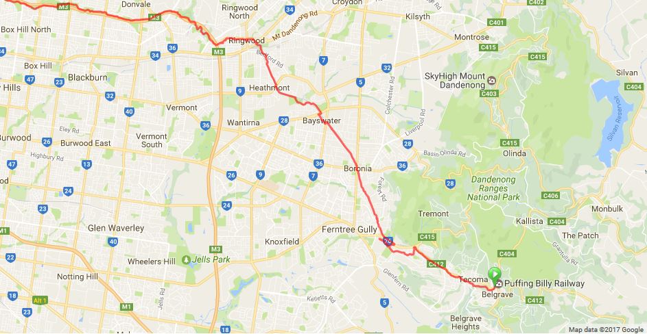
North Balwyn to Belgrave
To begin my round trip, I rode to Ringwood Station via the Bushy Creek Trail, Springfield Road and the Eastlink Trail. Along the way, I discovered the usefulness of Springfield Road as a direct east-west route between the Bushy Creek Trail in Box Hill North and the Mullum Mullum Trail in Mitcham. It has a gradient gain/loss difference of 60 metres and is about one kilometre shorter than the conventional route via the Koonung Creek Trail. As an added bonus, it has painted bike lanes along most of its length.

The final section to access Ringwood Station is part of the under-construction Box Hill to Ringwood Trail. There are some serious problems with this short but important path between the Eastlink Trail and the station, not least the unnecessary and lengthy wait at the pedestrian lights crossing Wantirna Road.
Here I boarded the train to Belgrave. The track follows a very scenic route through the foothills of the Dandenong Ranges through some pretty remote stations surrounded by bushland. You can also get occasional glimpses of views across the valley from the train once you pass through Ferntree Gully.

After this leisurely train journey, I arrived in Belgrave where the Ringwood to Belgrave Trail begins (or ends, depending on the direction in which you are headed).
Belgrave to Ferntree Gully
First off, let me say that the wayfinding for this section was among the worst that I have ever encountered. I have submitted my feedback to the Shire of Yarra Ranges who I hope will take this up and find a way to rectify the many issues along the path. I will go into more detail below, but I won’t cover every problem along this section because that alone would easily fill up thousands of words.
For those who are interested, I created a new Flickr album to display these issues. Inspired by the experience along this trail, it collects photos of decision points where signage is inadequate or absent entirely. Enjoy.
Meanwhile, back in Belgrave, after a few minutes trying to work out where the trail began (no signs at all), I worked out its route and set off along the alley behind the Belgrave shops.

Between this point and Upper Ferntree Gully, the scenery is very pleasant. The path winds its way through bushland and scrubland that occasionally resembles what you might find in one of the higher reaches of the Dandenongs.

Unfortunately the path surface is pretty atrocious in this area. It was sealed with asphalt, but it was the sort of asphalt that made you pine for gravel and dirt. Tree roots and soil erosion had created many large and quite dangerous potholes and bumps in the path. I also found this situation on the path near Upwey that I reckon is a good contender for the ‘not my job’ award.

This section also contained a number of thoroughly confusing decision points where I would have been completely lost had it not been for my trusty phone map. Numerous points in Tecoma, Upwey and Upper Ferntree Gully had absolutely no signage to indicate the direction in which pedestrians or cyclists should continue if they wish to follow the path. One of the best examples of this was at Tecoma Station where the most obvious route is in fact not the correct option.

As I continued down the path, the wayfinding slowly improved, although there were still many intersections that were confusing throughout Upper Ferntree Gully and Ferntree Gully. In these cases, it wasn’t necessarily a lack of signage that frustrated my attempts to follow the path, but rather badly-placed or incomplete directions.
These areas were also, predictably, car-dominated. I hardly saw anybody around who wasn’t in a car or truck. Between Belgrave and Ferntree Gully, I saw a grand total of two other people on the shared path, even though it was a warm and sunny day. A couple of the usual little things gave indications of its dominance by motor vehicles, including pedestrian lights that took forever to change and a ghost pedestrian crossing that I can only assume was removed to avoid inconveniencing cars.

As an aside, Hansen have done a detailed Streetscape Design Project for Upper Ferntree Gully outlining a lot of the issues in the centre with potential solutions.
Ferntree Gully to Ringwood
At Ferntree Gully, the Ringwood to Box Hill Trail is quite broken. The path suddenly deviates into the station carpark (again, without any signage or wayfinding assistance). I can’t imagine a family with children feeling very safe riding bikes through a huge surface carpark with cars darting in and out of spots (without looking) every few seconds.

The next two suburbs, Boronia and Bayswater, were not pleasant places in which to hang around for very long. The car-saturated Boronia Junction looked and felt very much like what a typical US suburb seems to be like. The area ticked all the boxes for an unpleasant environment for people:
- Insanely wide intersection (Dorset and Boronia Roads)
- Quadruple slips lanes
- Surface carparking surrounding the shopping centre
- High speed limits
- Very little greenery or shade
- No pedestrian access to the shopping centre (at least none that was obvious)
I would say congratulations, but it’s not something that should be a source of pride.

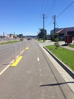
Moving along to Bayswater, I was able to have a quick look around the workings of the level crossing removal project that is now in its final stages. To my pleasant surprise, the Level Crossing Removal Authority had installed temporary bidirectional separated bike lanes on Power Road to replace the shared path that was within the construction zone. Much kudos to the LXRA for accommodating bikes in their project, something that is all too rare in construction zones around Melbourne.
Unfortunately, this run of good infrastructure ended at Scoresby Road. Again without any directional signage, I went down Station Street which was quiet enough for my purposes. Once I reached the Mountain Highway, the ‘traffic sewer’ of Daniel Bowen fame, I was thoroughly confused on which way to go once again. This lack of signage was compounded by a lack of crossing facilities across the brand-new road. Not only did the intersection with Station Street not have a pedestrian crossing on the eastern side, but the next closest one to cross onto the temporary bike route was all the way up at Scoresby Road (a 500 metre gap).

If a bike rider was coming in the other direction from King Street, it would be necessary to either dismount, walk on the footpath about 250 metres up to the Station Street intersection and wait for two pedestrian lights before being able to resume cycling down Station Street. Apparently there is a shared path bridge that is open to avoid the Mountain Highway, but I couldn’t find it anywhere (can’t seem to find it on Nearmap either). I also saw other individual and grouped cyclists looking equally as confused and lost as I did in the few minutes that I was there.
I’m sure the permanent solutions will be sorted out once the works are completed and this was a much better experience than many other construction projects, but there is still plenty of room for improvement. The station seems to be coming along nicely as well (which incidentally has one of the nicest backdrops of any station in Melbourne).

A short ride along the Dandenong Creek Trail brought me to Heathmont, a station that was grade separated some time ago.

Again, the wide lanes and fast-moving traffic along a major through road destroyed any inclination that I might have had to stay a while in the area. Canterbury Road presents a significant barrier for anyone trying to get from the railway station to the shopping strip in the service lane on the opposite side of the road.

A few kilometres further along finally brought me back to Ringwood. The entrance along this path to this major activity centre is undoubtedly more pleasant than approaching it in a car. The narrow path gently guides you down towards Ringwood Lake, a relatively serene and green haven in the midst of traffic highways and low-density suburbia. It is ringed by walking and cycling tracks and seemed to be teeming with birdlife. Perhaps unsurprisingly, this was the only place on my entire trip where I saw groups of people in any significant numbers not inside cars or at shopping centres.

One final point to note about Ringwood was the excellent traffic calming along Larissa Lane, a street that runs north off the Maroondah Highway opposite Ringwood Lake. The street has been narrowed in several places to one lane with speed humps, green buildouts and very limited carparking. From what I saw, it works very well at limiting car movements and limiting whatever traffic there is to a reasonable speed. Kudos to Maroondah Council for this project.

Summary
The ‘trail’ as named on maps and in council strategies, is little more than a series of poorly-connected paths that happen to run from one end to the other if you manage to find your way. There is a lot of potential to improve these small connections and make the Ringwood to Belgrave Rail Trail a ‘proper’ route with adequate signage and safe separation from traffic.
Leave a Reply