
After Monday’s sometimes-frustrating walk through Doncaster, it seemed that a more relaxing walk through some bushland would make a nice change. Unfortunately, it was not all smooth sailing.
Bolin Bolin Billabong
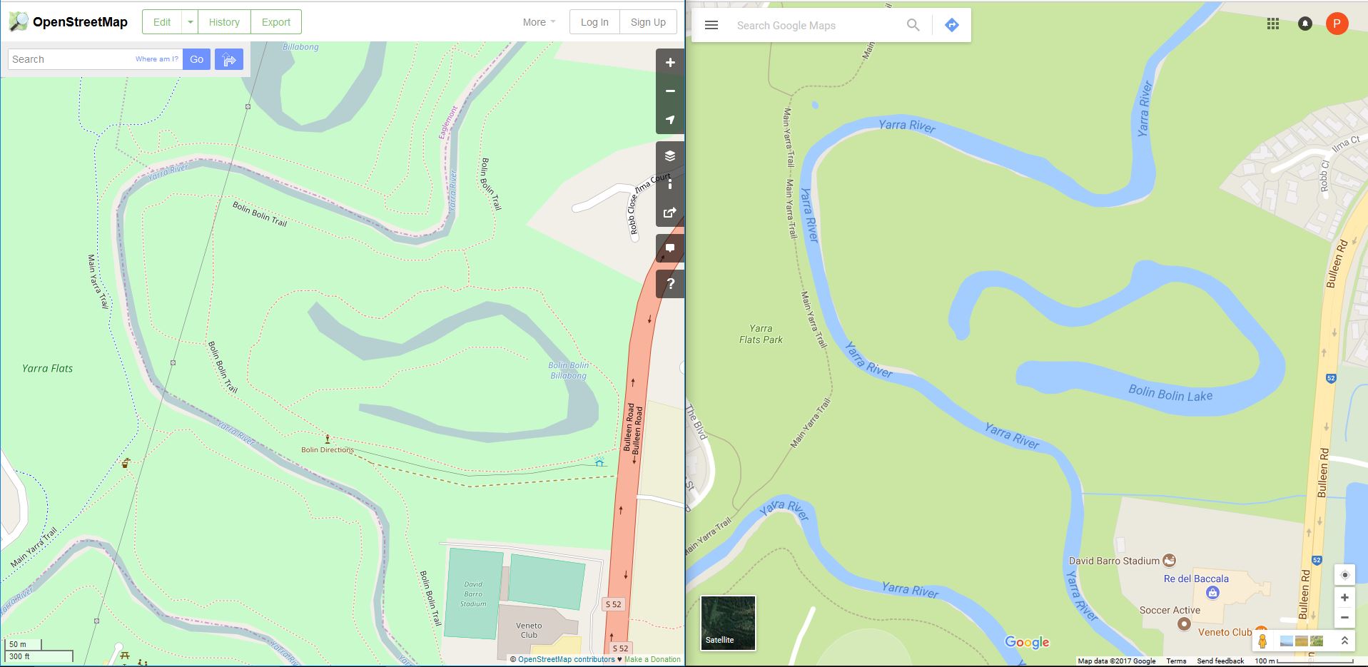
The Bolin Bolin Billabong is one of my favourite local places to visit. It is sandwiched between Bulleen, the Yarra River and the sporting fields in the Yarra Flats floodplains. The Billabong proper is accessible from Bulleen Road or from walking tracks running north to Banksia Park and south to the Koonung Creek Trail.
[leaflet-map lat=-37.760672785359546 lng=-214.91266250610354 zoom=12]
[leaflet-marker lat=-37.76932387363777 lng=-214.92356300354004]
I have spent quite a bit of time mapping this area on OpenStreetMap. As usual, I would advise against using Google Maps because very few of the paths through this area are displayed – another victory for open source crowdmapping!
Getting to the Bolin Bolin Billabong
Despite its close proximity to large swathes of residential areas to the south, east and west, it is surprisingly inaccessible. There is no bridge that directly connects the Main Yarra Trail on the west side of the Yarra River and crossing Bulleen Road from the east is difficult given the lack of safe crossing facilities.
I have to approach from the south, which is probably the least pleasant of all options. It is possible to use side streets to get to the Eastern Freeway, but the only way to proceed further is to walk along Bulleen Road.

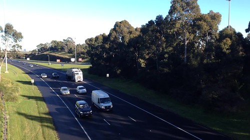
At this point, the road has a 70km/h speed limit, carries lots of traffic (including trucks) and leaves the footpath dangerously close to the roadway. The noise and fumes are overwhelming. It is difficult to accurately describe the experience without physically being there, but this video gives a small taste of the conditions (with a view of the Eastern Freeway).
At this point people have no choice but to use this bridge and road to travel north-south. There is no other way to cross the Eastern Freeway and continue your journey unless you want to go kilometres out of your way.
This becomes even more frustrating when you reach a service road for the Carey Sports Fields after crossing the Eastern Freeway and find that the shared path suddenly ends. Bikes are expected to use the on-road painted “bike lanes” (again, this is a four-lane 70km/h road with trucks) which also disappear further up the road anyway.

Trying to cross onto the other side of the road at this point would be suicidal. Even if you did somehow make it to the other side without being killed, there is no footpath there either – only a wide gravel median.

The only practical alternative is to walk down the service road into the parklands to the left which, of course, has no footpath.
As mentioned earlier, the facilities for bicycles here are also unnecessarily bad. There is plenty of room on both sides of Bulleen Road for some sort of separated shared path or cycleway, but instead there are only painted “bicycle lanes”. I tried cycling here a few years ago and quickly gave up after two terrifying close passes from massive semi-trailers barelling along at 70km/h. I would challenge whoever designed this and thinks that this merits bicycle infrastructure to ride along this stretch of road on a weekday.

Yarra Flats
I think that’s enough complaining for now – let’s focus on something nice!
The diversity and amount of bushland and wildlife around Yarra Flats is not easily found in any urban area. The plentiful water supplies, extensive native vegetation and distance from normal human activities seems to attract a lot of animals, especially birds, to the Billabong and its surroundings.

In the 90 minutes or so that I was there, I saw or heard lots of different birds which are not generally found in Melbourne’s built-up residential zones. These included the Grey Shrike-thrush, Superb Fairy-wren and Eastern Whipbird.

Walking around the Billabong itself means that you can also hear frogs croaking from below. While there has been some infestation by invasive plant species, quite a bit of rehabilitation work has been done in the past and is continuing now in two separate projects.
One is the implementation of a water management strategy for the whole area by the City of Manningham in partnership with the City of Boroondara and Melbourne Water. The other project currently being undertaken is for rehabilitating the Billabong itself. In partnership with local indigenous people, the entire area is being revegetated and improved. It should be terrific once this is completed.

My original plan was to continue north into Banksia Park and loop south to walk back home. Unfortunately, the issues with this path that I first saw in 2014 have still not been resolved very well. The path shown in that photo has finally been fixed, but new problems have emerged further north. The path goes through some low-lying floodplains and often floods. One particular creek/drain outlet needs a small bridge to cross, but this seems to have either been removed or washed away. My money is on the former given how cleanly and neatly the wood seems to have come off its piles.

Either way, this makes it impossible to continue. It is quite a trek to walk all the way back and around side streets in an industrial area to access Banksia Park or the Main Yarra Trail. And, of course, there are no crossing facilities unless you want to go a kilometre out of your way and cross the River on Banksia Street or enter the park from Bridge Street.
Despite these serious access problems, I can highly recommend a visit to the area. Even if you are not a nature lover or birder, it is a nice spot to sit or walk around and enjoy the peace and quiet.
Leave a Reply